logo

Generate diagnostic reports for real estate, environmental and carbon credits potential.

Find out your area’s potential with Moss Forest’s reports

Understand how we use DMRV technology and specialized technical expertise in the Amazon and its application on your property.

Our reports provide land diagnostics, environmental assessments, and the potential for carbon credit generation.

Choose the best option, submit the data for analysis, and uncover the potential of the property through the technology and efficiency of Moss Forest.


Land and Environmental Diagnosis

For a preliminary diagnosis of the property’s legal status at the time of analysis.

logo moss

We will redirect you to a contact form with the Moss Forest team.

Recomendado para

  • Land owners
  • Law firms
  • Environmental consultants
  • Diligence to buy carbon credits

What does this solution offer?

  • Identification of vegetation, soil, and biome
  • Identification of geological and geomorphological characteristics
  • Identification of the property in the Real Estate Registry Office and SICAR
  • Diagnosis of the land situation from INCRA-SIGEF
  • Diagnosis of the environmental situation (we check if there are overlaps with public areas, embargoes, deforestation, among others)
  • Analysis summary

Pre-Analysis for Carbon Credits

To learn about the area’s potential for developing carbon credit projects.

logo moss

We will redirect you to a contact form with the Moss Forest team.

Recomendado para

  • Land owners
  • Environmental consultants
  • Carbon credits developers
  • Diligence to buy carbon credits

What does this solution offer?

  • Identification of the property in the Real Estate Registry Office and SICAR
  • Diagnosis of the land situation from INCRA-SIGEF
  • Diagnosis of the environmental situation (we check if there are overlaps with public areas, embargoes, deforestation, among others)
  • Analysis summary
  • Analysis of more than one area at a time
  • Maps of land, environmental and overlaps analyzes
  • Identification of land use
  • Use of artificial intelligence for predictive analysis (future behavior)
  • Satellite geoprocessing information
  • Estimation of the potential for carbon credits and revenue generation

Moss Forest subscription

To have access to analyses of one or more areas, according to your specific needs, and monitor data with more flexibility.

logo moss

We will redirect you to a contact form with the Moss Forest team.

Recomendado para

  • Land owners
  • Law firms
  • Environmental consultants
  • Carbon credits developers
  • Diligence to buy carbon credits

What does this solution offer?

  • Identification of vegetation, soil, and biome
  • Identification of geological and geomorphological characteristics
  • Identification of the property in the Real Estate Registry Office and SICAR
  • Diagnosis of the land situation from INCRA-SIGEF
  • Diagnosis of the environmental situation (we check if there are overlaps with public areas, embargoes, deforestation, among others)
  • Analysis summary
  • Analysis of more than one area at a time
  • Maps of land, environmental and overlaps analyzes
  • Identification of land use
  • Use of artificial intelligence for predictive analysis (future behavior)
The carbon credit market has the potential to generate 250 billion dollars by 2030.Imagem de uma seta para direita

Some of Moss Forest's deliveries

Land overlap: through SICAR (National Rural Environmental Registration System), it is verified whether the analyzed area is registered and certified by the competent authorities and/or overlaps with third-party properties.


Carbon credit potential: Moss Forest calculates an estimate of VCU taking into account the conserved forest or the reforestation potential of the analyzed area.

Identification of deforestation: we identify deforestation according to the databases of the Project for Measurement of Deforestation by Remote Sensing (PRODES).

Identification of embargo/environmental notification: identification is carried out through the databases of ICMBio (Instituto Chico Mendes de Conservação da Biodiversidade) and IBAMA (Instituto Brasileiro do Meio Ambiente e dos Recursos Naturais Renováveis), collected by Moss Forest. We can verify the type of environmental infraction and the year in which the embargo or notification by the environmental agencies occurred.

Explore the Details of Our Reports

Regulated properties enhance forest protection and rural development.
 

imagem de um papel

Real estate regulation
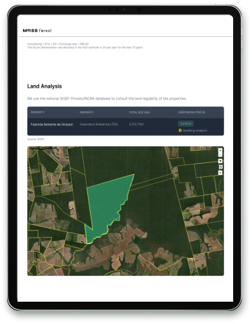
This is the prior analysis of the documentation that proves that a person or company owns a certain area.

imagem de um papel

Technology combined with the evaluation of Real Estate Law experts
We use the SIGEF/INCRA Brazilian database and have a legal technical team that assesses the status of registration and documentation of the area.

Imagem do app moss-forest

Without Moss Forest

•  Properties analyzed one at a time
•  Numerous trips to the field
•  People analyze images and databases one by one
•  Thousands of individually measured trees
•  Conservation and reforestation projects take much longer to get off the ground
•  It is a slow and costly process


With Moss Forest

•  Multiple properties analyzed at once
•  Uses Big Data to integrate satellite images, scientific studies and diverse databases into a single data lake
•  Automated analysis via high-definition satellite imagery
•  Various conservation and reforestation projects come to life in much less time
•  It is an agile and cheaper process

This is how technology protects the forest!
 

logo moss